Flying Labs to Make Drone Data More Actionable by Expanding Partnership with Picterra
June 12th, 2019

The value of the data collected by drones lies in improving decision making. For instance, improving city resilience implies a series of decision on future infrastructure standards, current infrastructure state, areas of high risk and budgetary constraints. Drones can collect very detailed information—high resolution imagery—on some of these aspects, but these are not enough for a policy maker to act one way or another. But the context created by grouping different facts together—the floodplain extent, the buildings locations, etc.—that creates a useful map of buildings located within a floodplain
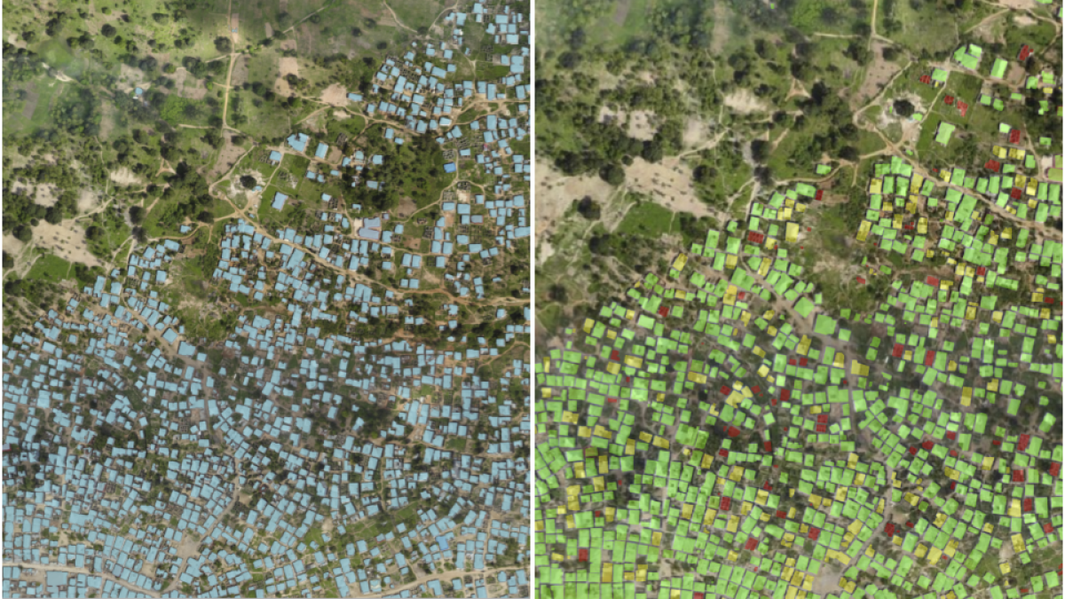
How does one go from detailed imagery to a floodplain map to make data actionable? It requires detecting buildings—and other relevant infrastructure—on the imagery, categorizing them and then analyzing the relationship between the different features and risk zones. How do we make data actionable by policy-makers and demonstrate the value of robotics and aerial mapping in the process? If the area is small, a lot of tools allow you to manually outline buildings, roads and other relevant features. This works well on small-scale projects, but what if we look at an area of 100,000 buildings? Manual digitization would take weeks and may lead to human error. There are algorithms that help automate this process, but these require investment in time and often don’t perform as well as expected without the thousands of samples—sampling which is a manual process is again time consuming and cumbersome.
In the picture above you can see a side-b-side one of the finalists of the Tanzania Open AI Challenge—vs Picterra custom detector. The latter only required 2 minutes of manual work. Photo credit: Anthropocene Labs
Picterra is proposing to help with that by using machine learning. Not only does the sampling required for detecting object is minimal, Picterra’s interface is very user-friendly and requires no coding. The Picterra platform can help detect from cars, to buildings, to sheep, to coconut trees. Since we have started collaborating with Picterra, they have put a lot of work into their platform and the result is very impressive.
Picterra and WeRobotics are expanding their partnership to bring this technology to the Flying Labs. All the Flying Labs will have access to Picterra’s platform and will be able to quickly detect object on high resolution imagery collected by drones. This will allow to develop custom detectors tailored to the local context and create dataset that are actionable to local policy makers.
"We are delighted to support the Flying Labs. In their hands, the latest breakthrough in Geospatial Artificial Intelligence meets the power of local engagement. We believe ensuring local communities to be able to automate geospatial information extraction autonomously will translate into positive social and environmental impact.
"We are delighted to support the Flying Labs. In their hands, the latest breakthrough in Geospatial Artificial Intelligence meets the power of local engagement. We believe ensuring local communities to be able to automate geospatial information extraction autonomously will translate into positive social and environmental impact," said Frank de Morsier, CTO of Picterra.
With Picterra at their disposal, detecting, counting and outlining more than 12,000 buildings in just a few minutes is now possible for Flying Labs. Naturally, Picterra's power is not only limited to detecting building infrastructure, so we look forward to following the work of Flying Labs as they apply Picterra to produce actionable analytics in other sectors as well.
Recent Articles

