
The Future of Impact Is in Collaborative Ecosystems
June 17, 2026
Systems change researcher Cynthia Rayner speaks about the power of collaborative ecosystems to create widespread social change that lasts.
May 24th, 2021

By Sikem Brice
Technology is increasingly having a transformative effect in the fight against climate change. The use of drones and various digital solutions, for example, has had magnanimous impacts on how climate change data is collected and shared. Actors in this sector are compelled to keep brace with this tempo of technological evolution or risks being obliterated from this course. The idea, however, that technology can serve as a silver bullet for addressing the many climate plagues of local communities is still out of reach. There are still many hurdles for inclusive access to technology, especially the digital space. For instance, lack of internet access for most rural areas significantly compromises their access to internet-based digital solutions. These communities may not be digitally literate to teach these technologies. Not just these, a further discord emanates from economic, social, and cultural disparities. Understanding these challenges in the climate change mitigation and adaptation sphere requires diligence for inclusive all-out community-centric interventions. Since winning the Unusual Solutions competition, we have sought to address these gaps in Cameroon by initiating a pilot project to drive technological inclusiveness in climate change responses in some three localities. The pilot project locations were selected based on their distinct socio-economic, cultural, and climatic factors.
From these bases, we led a twofold strategy for climate data collection, analytics, and comprehension:
Technology has played a prominent role in each stage of this project. Our field data collection used drones and satellite image interpretation, likewise processing this data with GIS techniques. It is essential to immerse the target population from getting go on the technologies to be implored. Of course, how can they understand the product if they do not understand how it came about? With the substantial groundwork already done in field data collection and analysis in these localities, the degree of climate impact revelations has been startling.
 Displaying how to play an environmental game during outreach campaigns
Located in the Sahel, this area in the extreme north region of Cameroon has had its fair share of the climate crisis. Seasonal droughts interrupted by torrential rains that cause severe flooding and the encroachment of the Sahara Desert into the region are just a few in a list of climatic problems at high threat levels in this region. About 90% of the population in Mayo-Danay is involved in agriculture as the main economic activity. The high-level sensitivity of agriculture to extreme climatic events wrestling this area has far-reaching consequences. The food security situation in this region is currently on alert, and as well, the area identifies among the areas experiencing extreme water stress in the country. Though poorly documented, displacement within Mayo-Danay and migration out of the region has been significant. There is a deep sense of lost hope among those severely affected by extreme climatic events. “There is nothing to go back to. We have lost everything to nature,” said Mouktar Aboubakar, head of the climate refugee camp at Kai-Kai. Two years after the last flood event, Mouktar and the rest of hundreds of refugees in Kai-Kai are not ready to go back. Year after year of losing love ones, property, and livelihoods to floods has convinced these people beyond doubt that their ancestral land is no longer livable.
There is nothing to go back to. We have lost everything to nature.
Stories like these set us out to have a deep understanding of these climatic risks in the region. Our main objective was to create climate change awareness through technologically inspired tools and develop other technological products with a community fit based on data gathered from this region. So far, our Arula game series is trending amongst the local populace, and calls for us to print and bring more is enough reason to convince us of the interest the population has in the issues. Using GIS techniques, satellite images have been analyzed, and maps about the climate impact situation of the region are now more apparent. There is now a pool of data on the climatic risks and inclusive community adaptation strategies to be deployed. Analyzed data will be visualized through appropriate media such as is in Residat and SMS platforms under development.
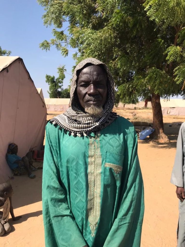
Aboubakar Mouktar climate refugee at Kai-kai refugee camp in Mayo-Danay
This maritime division in the coastal region of Cameroon has in recent years seen droves of climatic woes. The area is host to Douala, which is the economic capital and the largest city in Cameroon. The pressure on land here is intense, resulting in unregulated construction in marshy areas and along flood plains. While flooding may seem to be the single most pressing ecological challenge, there is a considerable conservation problem. The presence of the Douala city has exerted immense pressure on the surrounding ecosystem accounting for the massive disappearance of mangrove forests. The disappearing biomass and massive unregulated construction have been synchronous with rising flood frequency and intensity. Unregulated construction along flood plains of the River Wouri has significantly increased flood vulnerability by a factor of ten. Recent flash floods of November 2020 that caused loss of lives and immense material damages are still fresh in the minds of city dwellers in Douala.
Our key mission in the area was to establish a flood risks assessment by analyzing field data and drone footages and the development of data tools to aid in understanding flood risks among the vulnerable populace. So far, flood vulnerability and impact mapping have been prioritized. While threats to conservation and natural habitat loss observed with disappearing mangroves and marshes of the Wouri region cannot be directly linked to climate change, they have far-reaching consequences escalating flood exposure and vulnerability. Watch out for our inspiring flood mapping of the Wouri area on our Residat platform.
 Drone image of construction at the marshy banks of River Wouri
Recent climatic events have brought to duel the status of Noun division as the breadbasket of Cameroon. Seasonal flooding of the Noun river has had farmland and villages destroyed. Drought conditions are equally on the rise, with the most impact felt in the agricultural sector and acute water crises for domestic purposes. As reported by the delegation for environment and nature protection in the Noun region, seasonal droughts have significantly reduced farmland production and increased pesticide use. The rainfall patterns have become more unpredictable, leaving local farmers confused about when to plant their crops. Heavy rains have led to an outburst of the river Noun, which floods and destroys farmland and property. We led insightful outreach campaigns in Foumbot and Foumban subdivision localities to involve the population in our intended activities. Games were distributed to help in climate change comprehension and their associated risks. Field data was collected through questionnaires, field observations, and drone imaging of Noun Valley. Flood and drought maps have been developed for the localities of Foumbot, Foumban, and Magba.
 Searching the sky for the drone in Noun
With the analysis and development of data from fieldwork, we now have first-hand information on the climate reality of the project areas. While we have exemplified the inclusive use of technology at the awareness and data collection phase, the stake of the community remains high in adopting the digital-based platform for SMS and Residat through which reliable information and guidance on actions that can be taken to increase the resilience of vulnerable communities and individuals will be made available.
